|
CanoeCountry.com recommends WA Fisher Maps for the Boundary Waters and Quetico Park. Only Fisher Maps are accurate enough to be used for finding
portages, hiking trails and campsites in the Superior National Forest, BWCA and Quetico Park.

Fisher Maps
offers secure online shopping for
Boundary Waters Map Orders and Quetico
Park Map OrdersAll visitors to Canada who enter "remotely," without crossing into Canada at a Border Crossing Station must be in possession of a Remote
Border Crossing Permit(RABC,) the permit is easy to get. Detailed instruction and the application can be found at: www.queticopark.com/rabc
See Native American pictographs in the BWCA and Quetico Park.
Planning Assistance
Purchase your Boundary
Waters and Quetico Park Maps here
Quetico Provincial Park Web Site
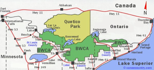
| BWCA Scenes
Image Gallery The Boundary Waters is part of
the National Wilderness Preservation System, maintained by the U.S. Forest Service. The
Quetico Provincial Park is operated by the Ontario Ministry of Natural Resources.
|
|